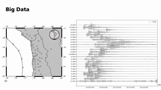
Earthquake Localisation
Autor
Beteiligtes Institut
Geophysikalisches Institut (GPI)
KIT-Zentrum Klima und Umwelt (ZKU)
Genre
Beschreibung
How can active fault systems be mapped using seismology?
Setup of a local seismic network, characterisation of seismic phase arrivals, traveltime inversion for earthquake location and minimum 1D model.
Laufzeit (hh:mm:ss)
00:09:28
Serie
Basic Geophysics - Working Groups at GPI
Publiziert am
21.05.2019
Fachgebiet
Lizenz
Creative Commons Namensnennung – Keine Bearbeitungen 4.0 International
| Auflösung | 1280 x 720 Pixel |
| Seitenverhältnis | 16:9 |
| Audiobitrate | 128000 bps |
| Audio Kanäle | 2 |
| Audio Codec | aac |
| Audio Abtastrate | 48000 Hz |
| Gesamtbitrate | 932792 bps |
| Farbraum | yuv420p |
| Container | mov,mp4,m4a,3gp,3g2,mj2 |
| Medientyp | video/mp4 |
| Dauer | 568 s |
| Dateiname | DIVA-2019-383_hd.mp4 |
| Dateigröße | 66.214.252 byte |
| Bildwiederholfrequenz | 25 |
| Videobitrate | 798701 bps |
| Video Codec | h264 |
Mediathek-URL
Embed-Code